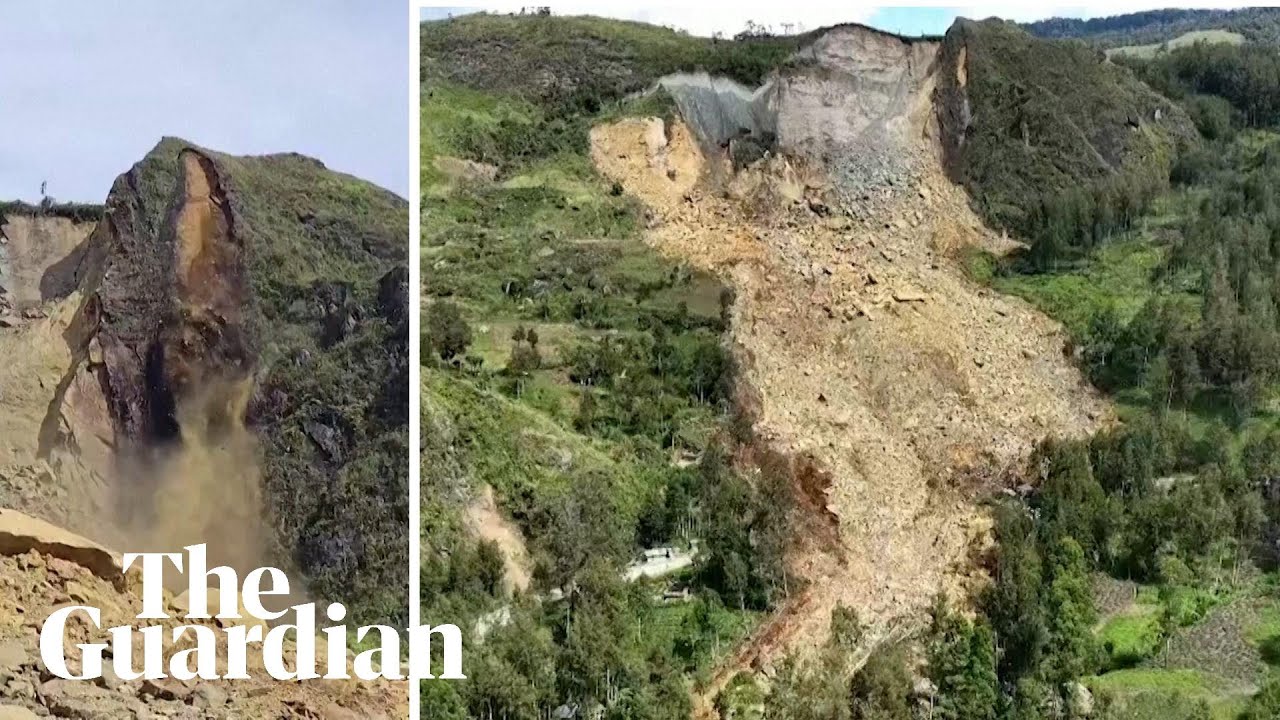
Hundreds killed after landslide flattens remote Papua New Guinea village
Hundreds are feared dead after a massive landslide levelled dozens of homes in a remote village in northern Papua New Guinea early on 24 May, according to a local resident.
Subscribe to Guardian News on YouTube ► http://bit.ly/guardianwiressub
The prime minister, James Marape, said authorities were responding and that he would release information about the destruction and loss of life when it was available.
The Guardian publishes independent journalism, made possible by supporters. Contribute to The Guardian today ► https://bit.ly/3uhA7zg
Sign up to the Guardian’s free new daily newsletter, First Edition ► http://theguardian.com/first-edition
Website ► https://www.theguardian.com
Facebook ►https://www.facebook.com/theguardian
Twitter ► https://twitter.com/guardian
Instagram ► https://instagram.com/guardian
The Guardian on YouTube:
The Guardian ► https://bit.ly/guardiannewssubs
Guardian Australia ► https://bit.ly/guardianaussubs
Guardian Football ► https://bit.ly/gdnfootballsubs
Guardian Sport ► https://bit.ly/gdnsportsubs
Guardian Live ► https://bit.ly/guardianlivesubs
#PapuaNewGuinea #Landslide #NaturalDisaster
40 comments
😢
Third world…..who cares?……😂😂😂
Hmmmm sus
Png gov now own around 50 % of Porgera goldmine nearby that had to reduce its ownership from canadian and chinese interests in order to get the permits to reopen early this year.
Was any further exploration/ mining being done on or under that mountain recently?
prayers
climate crises
🥀
Rip to those who died 😢😢
💔💔💔💔💔
Saying over 670 people now! OMG! These poor people.
Keep the praying to yourself, hypocrites. Maybe they learn something, don't build a new house there. Simple
This happened in Afghanistan and iran too 😢
So where are the Chinese now?
Sending my condolences to Papua New Guinea.
More climate engineering
Bad place to make a village
I'd really love to help. Caveat: whoever is sent to help could end up on the lunch menu! 😱
Quantum is conscious. PNG is a place severely lack of love and compassion, hence the consequence.
What did you do in UN voting over Palestine?
It’s strange that no one blamed America for what happened
One thing is a bit weird. When you look at the Location of the Landslide on satellite Images, there are only around 5 Houses and the Landslide itself isn't that big. How is it possible that so many People are burried? Also they talk about the entire Villages destroyed but there are only a few houses and only forest. Did i miss something or can Someone explain it?
Google Earth these pre-landslide coordinates and tell me if you think 5,000 people lived here: 5°22′26″S 143°23′19″E
It looks extremely rural and sparsely populated for the death toll to be that high.
Meanwhile, the MPs are busy with the VoNC and not sure who will be addressing our people there. Sorry 😔 for the losses
Thousands yet no mainstream reports and such less views, please remember community is small and a big impact, one of the most unique and isolated, oldest indigenous of any region, also not fair to divide island in the middle in a straight line, in lndonesia daily targeting and its trees being chopped too.
Israel come to help!??
The lack of news coverage on this has been absolutely disturbing
🙏😢
Dziekuje krol z Jordani i szwab😢
Why's earth gone mad?
help israel
Pray and love from Indonesia.. My condolences 🙏
The village must have only been established only a fairly short time ago as I came across a satellite image of the mountain after the landslide, however I managed to find another satellite image of the exact location before the incident and the whole area appeared to be almost completely uninhabited at the time. I read somewhere that the village acted as a base camp for miners in the area or something, hence the seemingly unusually high death toll.
😢😢
News agencies
300 people killed
Another news agency: 2000 people killed
Broadcasting information with different outcomes
Such a terrible news this is. Prayers are with the people affected by this landslide
I call major BS on any claims of mre than 20 or so dead. You dont need to be a galaxy brain to take one look at the population density here to realise estimates of 670 to 2000 are preposterous.
Strange: According to Google Earth and Google Maps, however, virtually no houses, huts, paths or dwellings can be recognized on the aerial photographs of the disaster area … so where should the high number of victims come from? 🤔
ada apa dengan gaza? 😂 kalian buta
India is with u ❤️🇮🇳🙏
2000 People and counting…
Horrific toll…
Their government who must step up…
🇿🇦
😂😂😂😂😂😂😂