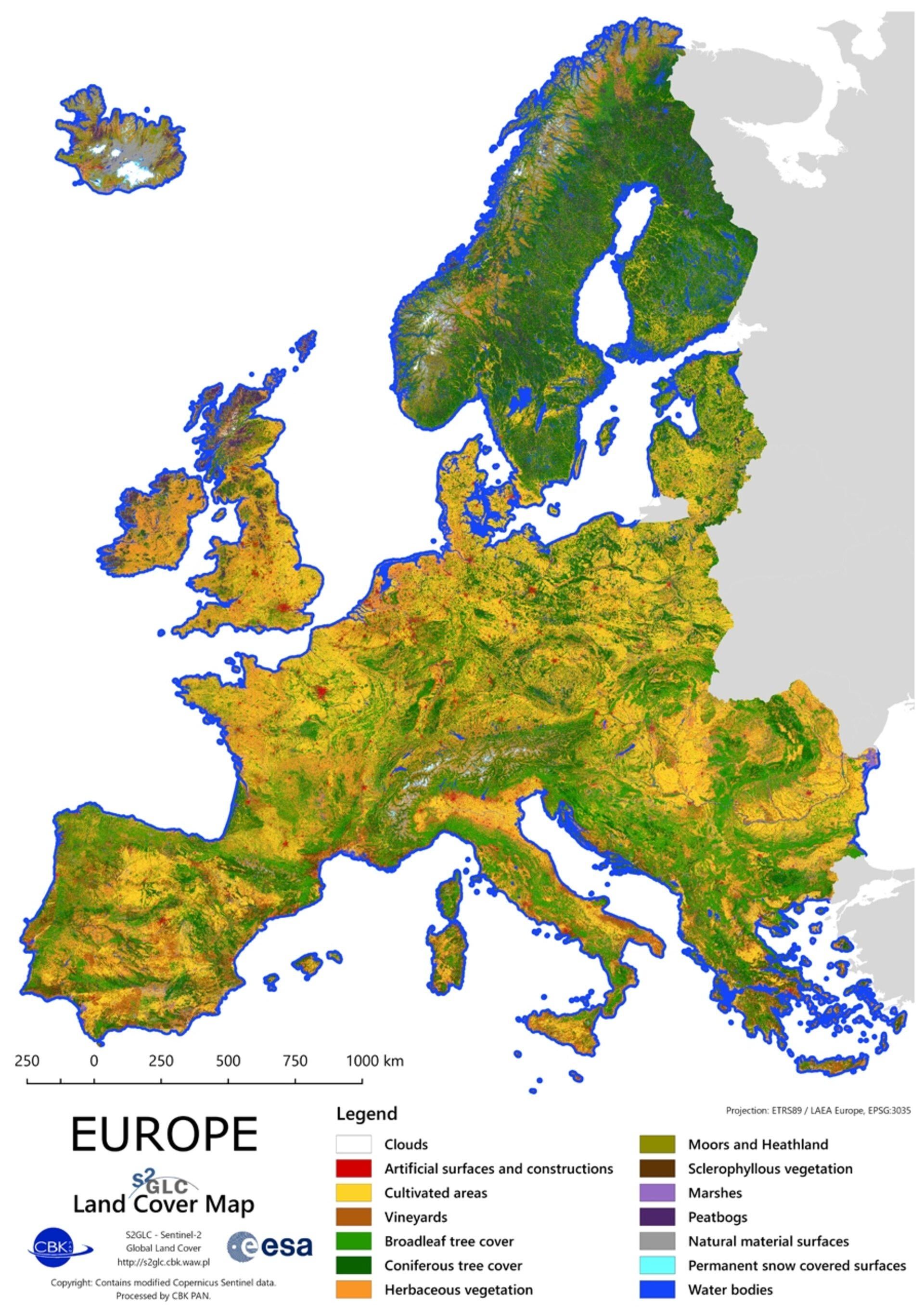
Romania has a LOT of cultivated area, but our farmers are underequipped, extremely selfish, while the government doesn’t help them except by giving money to select few while raising taxes. We could literally be the bread basket of the EU, but oh well, we can’t even grow food for ourselves, we even import most of that
For Portugal, it used to be way more green in the costal are up until a few years ago almost all of it was gone in a huge forest fire. As someone that grew up in the region that is now all burnt, it hurts my heart seeing it. Its like a war was fought there. For people in my home town, lossing our forest was like loosing a family member.
I knew it! Most of the world ocean is just clouds!
Where are the biggest clouds areas of land?
Is the white in Iceland supposed to be white as in clouds as the legend says or is it meant to be permanent snow covered surfaces as its surroundings is?
Is Ukraine not Europe? Or Belarus? Curious as to why some maps include them and some don’t.
Do you have a link to the original source? Because this is definitely not 10 metre resolution anymore, after whatever it went through during the upload
Edit: Found it by following the link in the bottom left, the full data with 10 metre resolution is a 16 GB download

14 comments
Romania has a LOT of cultivated area, but our farmers are underequipped, extremely selfish, while the government doesn’t help them except by giving money to select few while raising taxes. We could literally be the bread basket of the EU, but oh well, we can’t even grow food for ourselves, we even import most of that
For Portugal, it used to be way more green in the costal are up until a few years ago almost all of it was gone in a huge forest fire. As someone that grew up in the region that is now all burnt, it hurts my heart seeing it. Its like a war was fought there. For people in my home town, lossing our forest was like loosing a family member.
I knew it! Most of the world ocean is just clouds!
Where are the biggest clouds areas of land?
Is the white in Iceland supposed to be white as in clouds as the legend says or is it meant to be permanent snow covered surfaces as its surroundings is?
Is Ukraine not Europe? Or Belarus? Curious as to why some maps include them and some don’t.
Do you have a link to the original source? Because this is definitely not 10 metre resolution anymore, after whatever it went through during the upload
Edit: Found it by following the link in the bottom left, the full data with 10 metre resolution is a 16 GB download
[https://s2glc.cbk.waw.pl/extension](https://s2glc.cbk.waw.pl/extension)
I like this map of Europe. 😊
It’s sad Ireland one of the most forested countries before is now the most deforested country in Europe after Malta.
UK looks not much better either. Ireland and UK look like a giant farm on this map.
Imo this map + Ukraine + Belarus and Moldova should be the max of the European Union.🇪🇺
The resolution on the map is shit
Well, now I know why there is Primitivo (wine) everywhere to buy 😀
(Apulia, aka the heel of Italy is its origin -> vineyards only)
UK looks miserable place, not any forest left
So almost no real nature left