The image is wrong.
Tower in brussels should have an evil eye on the top.
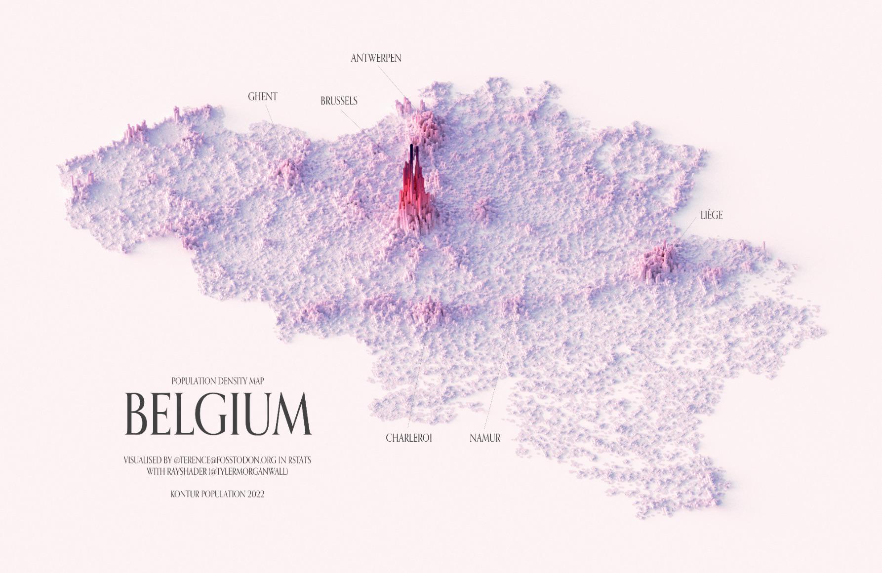
Since when is there a city as large as Brugge in the middle of de Westhoek
Those spikes around Alveringem? Nah. Something aint right.
Look how much parking there is all around Brussels!
Ki da crazy how we’re still one of the most densely populated countries in the world, yet so much open space too
Even on this map, our coast line is ruined by apartment towers…
And in Wallonia, you can actually see the Sambre-et-Meuse river – that line from Charleroi to Liège, with Namur being that bump along the way.
EDIT: fixed name of river
This map is a little misleading.
Population density in antwerp and gent is less than in brussels. But not by that much.
I guess all the surface area in the harbors and industry around both cities pulls the avg/km2 down?
En ik dacht dat al de rest parking was! My life is a lie!
And yet all the flights in Zaventem go through the huge population tower instead of using the farmers no man’s land around
That’s beautiful!
Hey! I can see my house from here
i wonder why kids from brussels feel the need to go to flemish recreational facilities what could be the cause of this?
This map is a map of apartheid.
So we have some densely populated cities, and some cities.
The province of Luxembourg seems quite empty.
Limburg really is parking
Antwerpen in English is Antwerp. Nice map, though.
Why does Brussels look Mordor? Coincidence? I THINK NOT
Sens like Liège us the 3rd densest region of the country according to this map

20 comments
Credit: https://fosstodon.org/@terence
Cool map. Yes, Brussels is dense!
The image is wrong.
Tower in brussels should have an evil eye on the top.
Since when is there a city as large as Brugge in the middle of de Westhoek
Those spikes around Alveringem? Nah. Something aint right.
Look how much parking there is all around Brussels!
Ki da crazy how we’re still one of the most densely populated countries in the world, yet so much open space too
Even on this map, our coast line is ruined by apartment towers…
And in Wallonia, you can actually see the Sambre-et-Meuse river – that line from Charleroi to Liège, with Namur being that bump along the way.
EDIT: fixed name of river
This map is a little misleading.
Population density in antwerp and gent is less than in brussels. But not by that much.
I guess all the surface area in the harbors and industry around both cities pulls the avg/km2 down?
En ik dacht dat al de rest parking was! My life is a lie!
And yet all the flights in Zaventem go through the huge population tower instead of using the farmers no man’s land around
That’s beautiful!
Hey! I can see my house from here
i wonder why kids from brussels feel the need to go to flemish recreational facilities what could be the cause of this?
This map is a map of apartheid.
So we have some densely populated cities, and some cities.
The province of Luxembourg seems quite empty.
Limburg really is parking
Antwerpen in English is Antwerp. Nice map, though.
Why does Brussels look Mordor? Coincidence? I THINK NOT
Sens like Liège us the 3rd densest region of the country according to this map